Kauri Cliffs. Premium Northland golf course. The facilities creek water rights were cancelled so they needed a new ground water well. A very successful well was drilled ensuring the facility has irrigation and service water.
A.I. Data Centre and Surf Park Central. This is a AI data centre and surf park development in Auckland New Zealand. A 700m deep well was sited and drilled to ensure a good supply of water was obtained. The area is a particularly difficult area being near the base of several old volcanos and is known as on the chaos formation. A large fracture system was located that has ensured an excellent supply of water ensuring the development can proceed as the local authority was unable to supply the development with water.
Carlyle Drilling. Carlyle is a leading New Zealand multi-faceted drilling contractor, and we have been mapping for Carlyle clients for 14 years. The Aquifer Mapping data assists the drillers in understanding what geology type and boundaries that are coming and ensures correct mud pressures are maintained. Also allows preplanning casings and screens requirements prior to drilling.
Mercury Energy. Mercury energy is a major geothermal energy producer in New Zealand. Hot and cold wells have been sited.
Basset Plumbing and Drainage. This company is a large manager of land developments. Aquifer Mapping has sited water wells for 3 developments for a plan of 5000 new houses.
Futon Hogan Land developments. Large scale New Zealand and Australian based land development company. New wells sited for a 4000-house development on Auckland’s North Shore.
Seeka. Seeka is one of New Zealand largest kiwifruit grower/packer/exporters. They needed a new water well for a large-scale development in the Bay of Plenty which was in a very challenging environment. Success and a 60,000 litre per hour well was the result.
New Zealand Steel. Aquifer Mapping sited two new very successful water wells for a land development owned by New Zealand Steel in South Auckland.
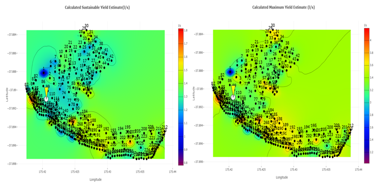
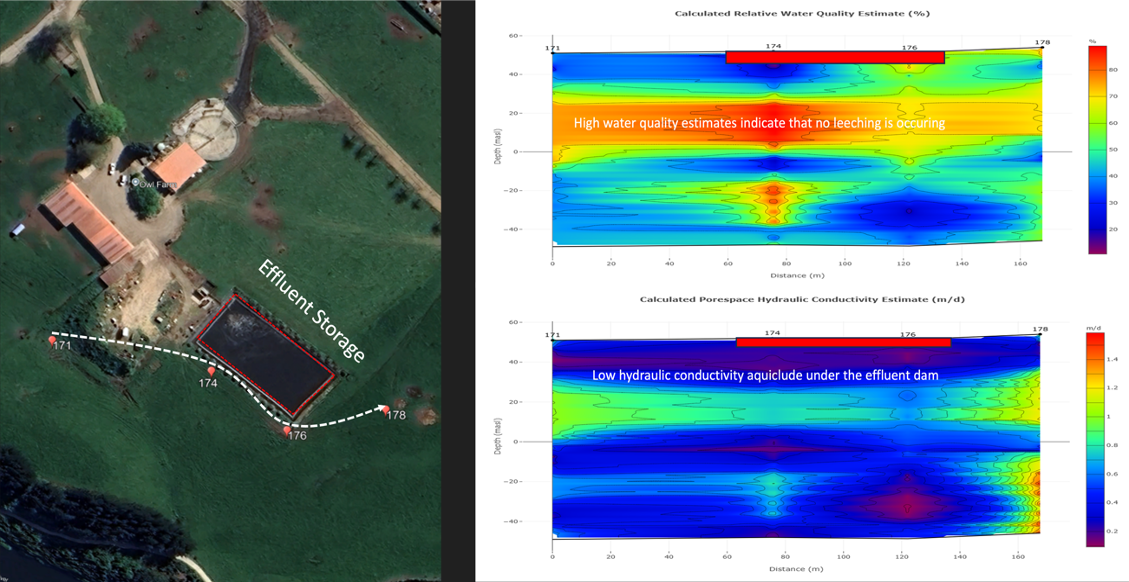
Owl Farm. Owl Farm is a high intensity dairy farm that is based on the banks of the Waikato River. They wanted to know how much natural water discharge was occurring from the farm into the river. They also wanted to know where not to spray effluent and if they needed a new water well where the best location was to drill that.
McKenzie and Co. Large scale land developer. New wells sited for a large housing development in Queenstown New Zealand.
Rotorua Lakes Council. Several hot wells have been sited for this client using the Aquifer Mapping system. Main use is heating large commercial properties and pool complexes. Aquifer Mapping also mapped the land out around the historic Museum to model where the thermal heat source was encroaching into the building’s footprint. This was successfully remediated with cold water injection on points located by Aquifer mapping.
Southern Cross Horticulture. SCH is a large-scale developer and operator of kiwifruit orchards in New Zealand. Aquifer Mapping has sited 25 wells for SCH, all which produce good water from a complex geological area.
Palmerston North City Council. PNCC own several deep community water wells. Their city is developing and they require more water. Several new water wells have been sited for them by Aquifer Mapping. The client also had a proactive approach to wanting to ascertain the sustainability aspect of their existing water wells.
B @ A. Barker and Associates are a high-powered consultant specialising in water use and environmental management. GeoVue has sited new water wells for one of their developments being a 2000-house land development.
Horowhenua Council. This client was faced with a serious reduction in production from one main city well. Aquifer Mapping mapped the old well and determined it has collapsed. 2 new well locations were sited.
Tenterfield Council – NSW Australia. This council was suffering major water supply issues. They had drilled 13 dry wells. An affiliate company of Aquifer Mapping was called in and a new well was sited. That well produces 30,000 litres of water per hour and effectively saved the town.
Ramco Ranch – Salinas – CA – USA. Aquifer Mapping were asked to map one of these operators 2000-acre ranches. The ranch was used to grow strawberries and was a heavy user of water. The client wanted to locate some new wells and had concerns as to where the fresh water and saline water interface was under their ranch given its proximity to the Coastline. Both client requirements were satisfied by Aquifer Mapping survey and the new wells that were drilled remain producing good quality and quantity water today.
Cold Storage Packhouse Development – BOP – New Zealand. A new large-scale development required a water supply. They drilled a new well and that was dry. They then got Aquifer Mapping in, and a drilling target was located. The new well produces 40,000 litres of water per hour.
Santana Minerals. Mapping quartzite veins and aquifer positions.
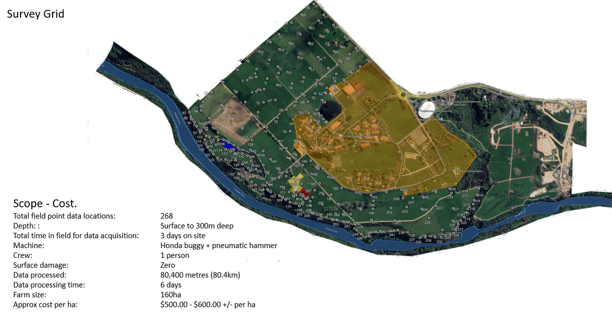
Technology demonstration on The Owl Farm that bounds the Waikato River.

1716 Cambridge Road,
Cambridge,
New Zealand 3283.
Mapped in 2025.
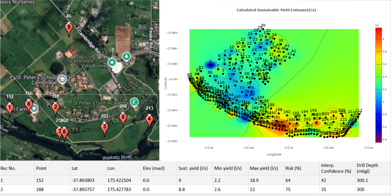
Owl Farm is a very well managed producing dairy farm located at 1716 Cambridge Road, Cambridge, New Zealand 3283. Year 2025.
Sustainable yield verse maximum yield estimates in litres per second.
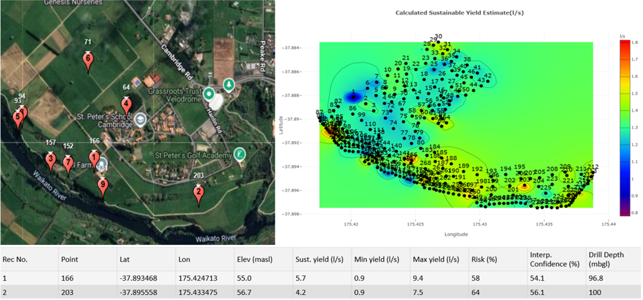
Drilling targets at100m depth. Pegged drilling locations. Top 2 selections noted below.
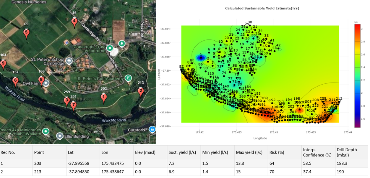
Drilling targets at 200m depth. Pegged drilling locations. Top 2 selections noted below.
Drilling targets at 300m depth. Pegged drilling locations. Top 2 selections noted below.
Some Discussion Topics.
•Recommend that client considers drilling 2 wells to 100m depth verse 1 well to 200m or 300m depth.
•The 100m wells should provide a combined sustainable flow rate of 10 litres per second (36,000 litres per hour).
•It is considered that two wells will lesson the exposure of pump failure.
•There does not appear to be other wells allocated to the 100m depth zone that could be affected by these new wells and the aquifer is not noted as over allocated.
•It would certainly be in the client's interest to get drilling quotes for 2 x 100m wells verse 1 x 200m well.
•Client to consider pump costs and getting services to well head. Often pump requirements for a 100m deep well are a lot lower than a pump requirement for a 200m or 300m deep well.
•It also to be considered that the 100m depth recommendation number 1 is very close to existing services so cost effective and a very good start.
•Further consideration could be given to increasing the diameter of well number 1. By enlarging the well diameter the production rate of the well will increase.
•What ever the client's decision they now have a range of very real targets and a clear understanding how their aquifers work.
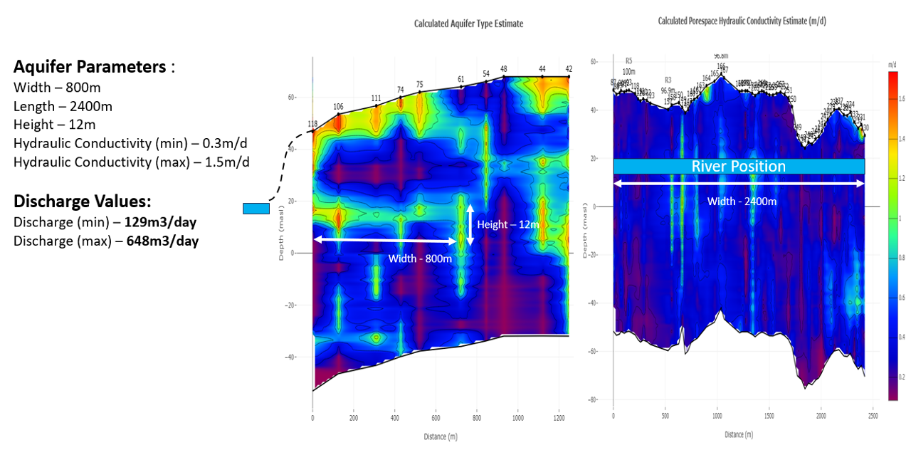
2D cross section view of the Owl Farm aquifers. Existing well data has been overlaid.

Natural aquifer discharge flow estimates into the Waikato River system.
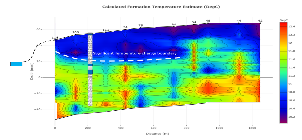
2D cross section showing temperature variance under The Owl Farm.
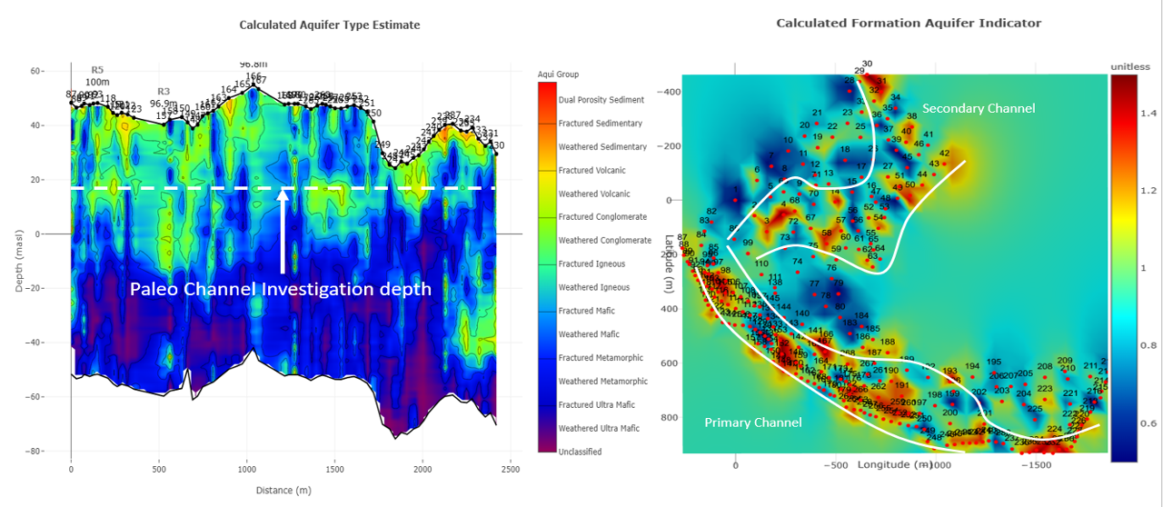
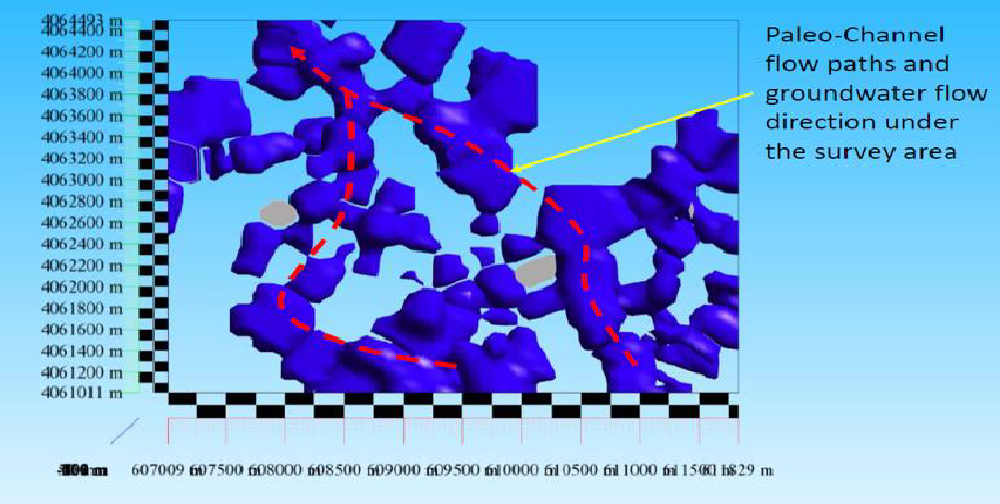
2D and 3D cross section ancient riverbed systems (paleochannels).
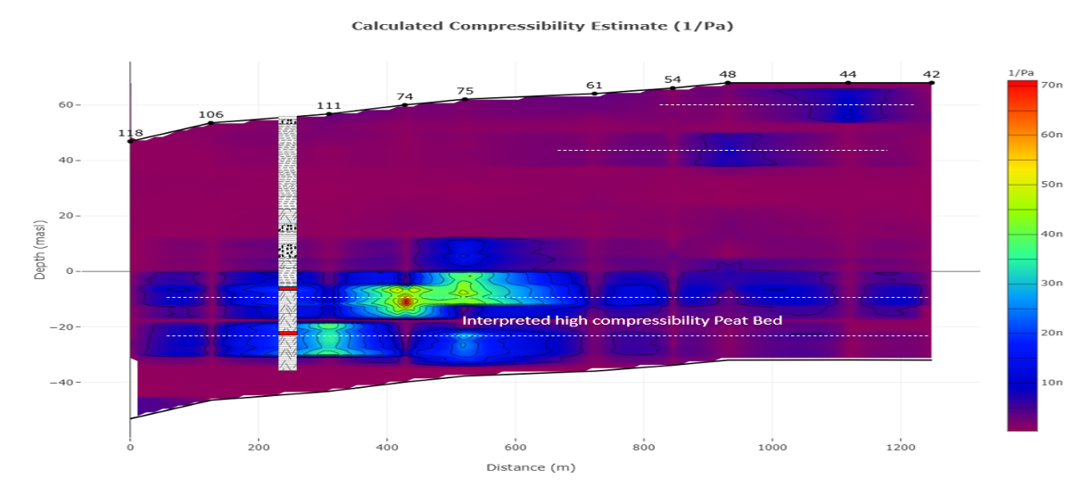
2D cross section showing peat formations.
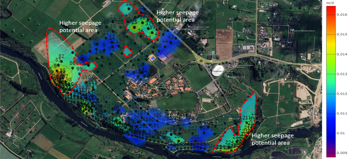
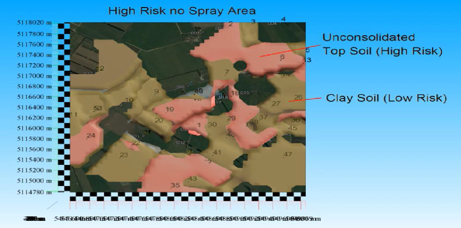
Surface map showing areas where care needs to be taken with the application of fertilizer programs.
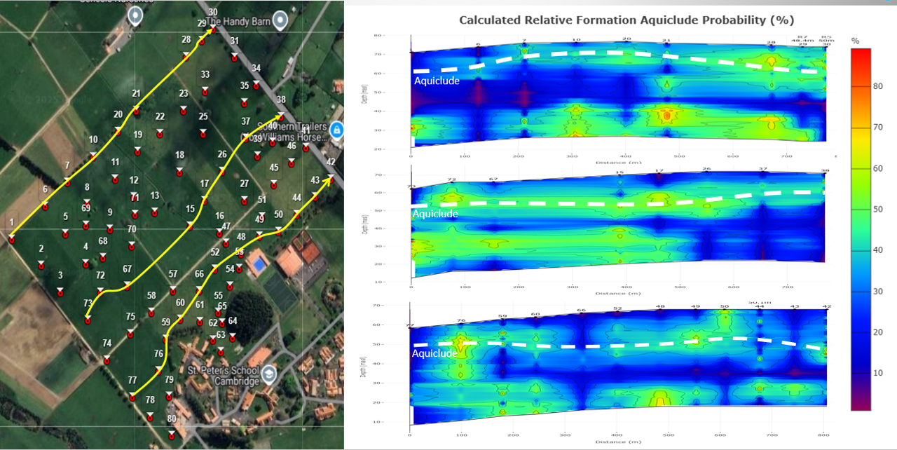
2D cross sections are showing the natural aquicludes (clay) under the site. These are good at keeping contamination problems near the surface.
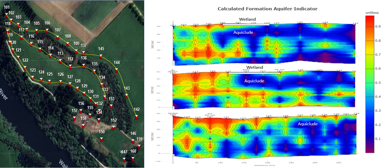
2D cross section view of the extremely well managed and designed wetlands on The Owl Farm.
2D cross section showing no leaching from effluent dam – excellent water quality.
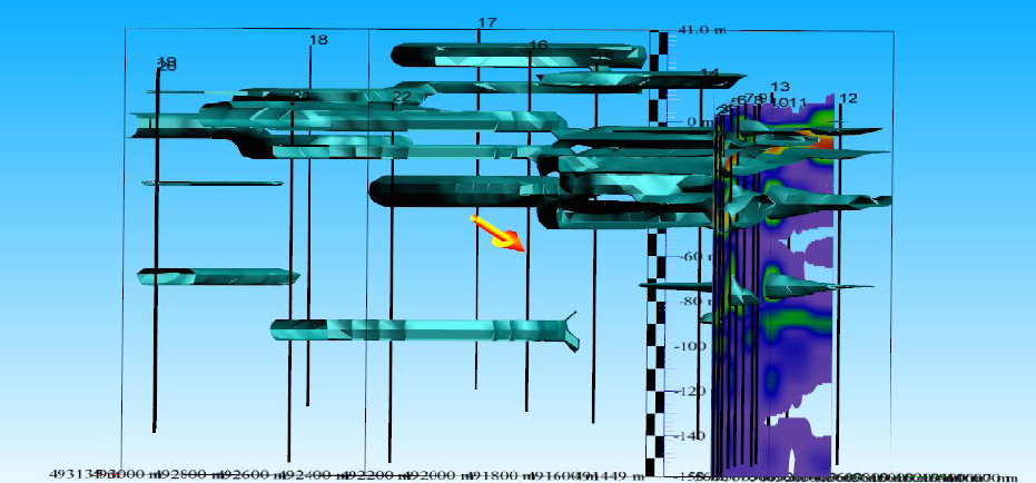
3D cross section showing aquifers under Havelock North. Note the aquifer interconnectivity.
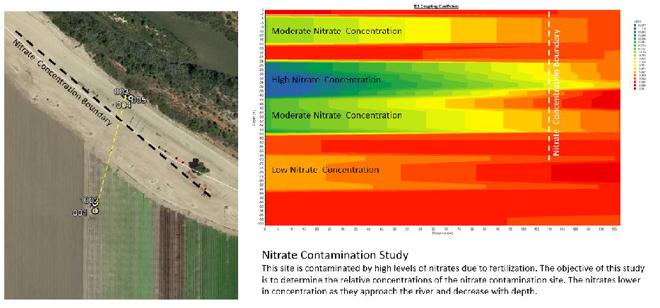
California. Nitrate boundary mapping.
Canterbury dairy unit.
3D surface map showing in pink where not to spray effluent given the high porosity of those soils. This is because those areas in pink allow direct
entry for water and contaminants to enter the shallow aquifer systems
California. Aerial view of aquifer at 700 meters depth showing the flow path of the aquifer in old paleochannel formations.
Total farm area was 2000 acres.
California. 2 x aerial views of the same property showing totally different flow paleochannels.
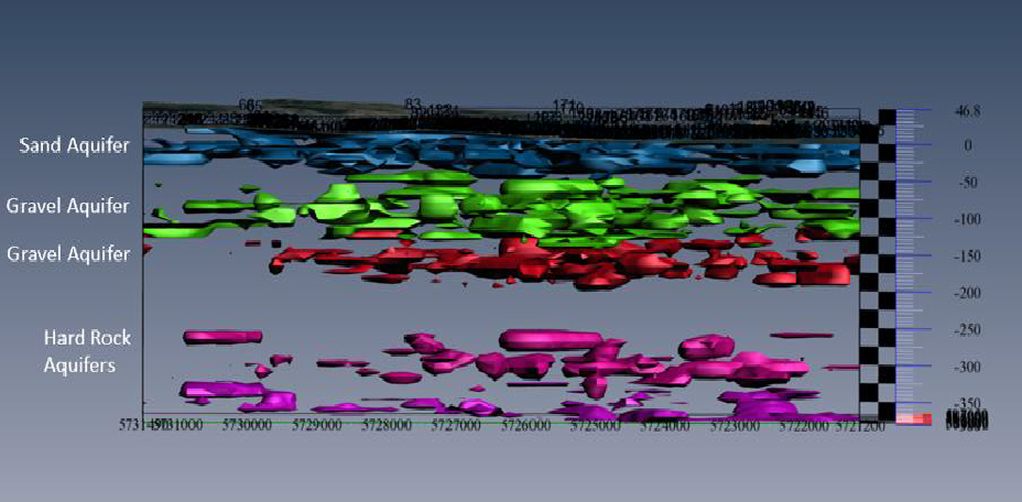
Gisborne New Zealand. 400m depth. 3D images showing 4 different aquifer types.
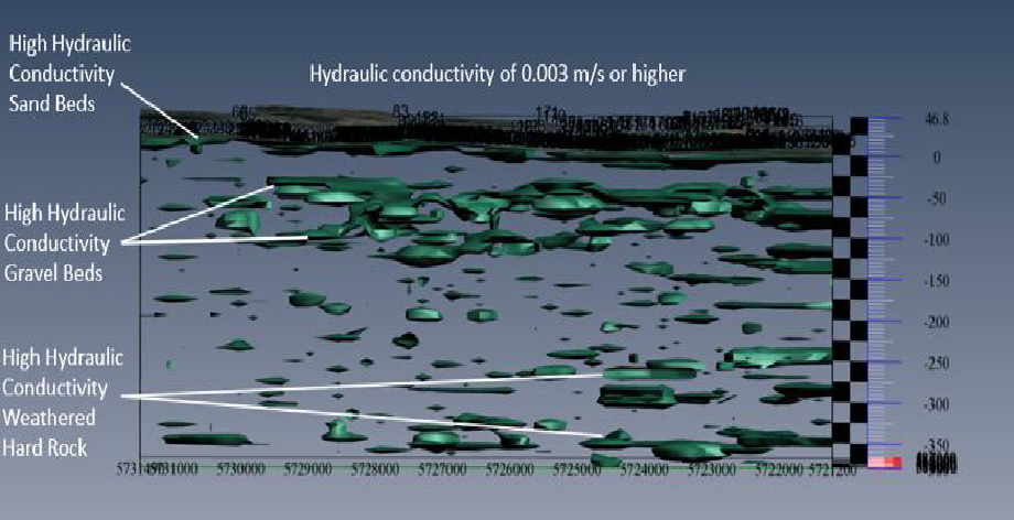
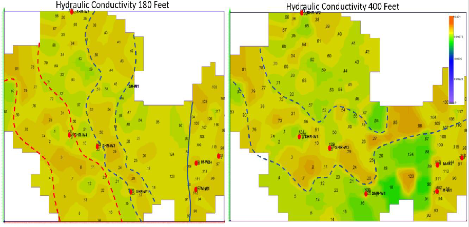
3D Hydraulic Conductivity estimates.