•Specialists in mapping aquifers using NZ made technology.
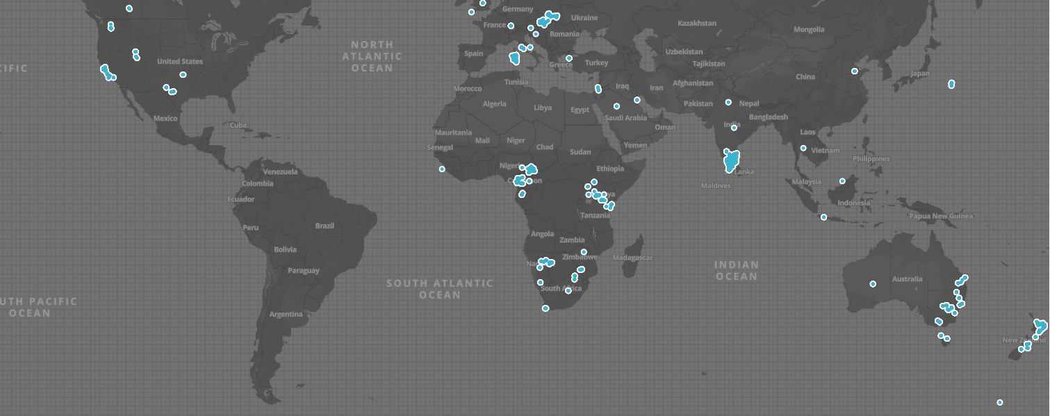
•10,000 water wells sited globally.
•Significantly reduces drilling risk.
•Assists with subsurface RMA environmental management (FEP).
•87% success rate globally on aquifer targets, aquifer production rates and geology boundaries.
•Assists with RMA water permitting.
•Cost effective – low environmental footprint – and you choose where to map.
•Based in Gisborne, New Zealand but mapping globally.
Crews in NZ, Australia, USA, Italy, South Africa and India.
To proceed with a no obligation quote reach out to info@aquifermapping.co.nz. If you are farming and want to know what a survey will cost please attach a farm map and farm address.
About Aquifer Mapping
Problems we solve
Do I drill a new well or not ?
An Aquifer Mapping survey will provide you with a clear recommendation on where, and why, to drill a new well.
How deep will I have to drill ?
You will receive a virtual well log for each reccomended drilling location. These show the depths to, and thickness of, the aquifer targets.
Well design planning can now take place prior to the drilling program ensuring an effective well completion program.
Can this tehnology provide us with a maximum, a minimum and a sustainable flow rate estimation?
Yes. All 3 are supplied.
Will this service help me get a Water Permit under the RMA?
Yes. Most authorities understand the value and in most cases they are seeing information they have never had access to previously so in short it makes making their decision making a lot easier and science based.
How long does a normal NZ dairy farm take to survey ?
2 Days.
How long does it take to get the results?
24 hours.
How do I know the location in my field where I am to drill ?
The Aquifer Mapping field crew will return to your site and peg the top 4 drilling locations for you. Standard system is a Waratah post and flag.
How accurate is this service?
Over 10,000 wells have been drilled using this technology and the success rate on hitting the aquifers and the geology boundaries is 87%.
I am concerned that if we drill a new well it may affect my neighbours existing well. Can this technology assist with detremining this and ensure we do not create problems for others ?
The answer is “yes” providing we can get access to your neighbors property / well. If access is not available we can map on your property as close as we can to understand the situation.
In a lot of cases we can locate a seperate aquifer that reduces any risk.
What can I expect to see in the paddock equipment wise?
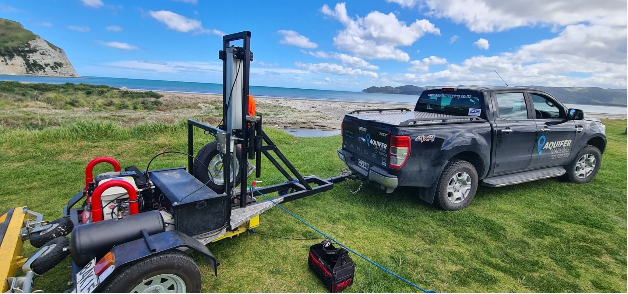
A Honda or Can Am side by side. Fitted to the bike is a pneumatic air hammer. Most rural crews are a one person crew.
How much does it cost ?
This depends on the size of the property, the number of field points completed and the depth of inspection.
Most dairy units over 100ha work out at +/- $750.00 per hectare.
Recent Projects Examples

Fulton Hogan Land Developments – New wells were sited for a 4,500-house development on Auckland’s North Shore.
Palmerston North City Council – Aquifer Mapping was charged to map the areas around all of the Cities water wells assessing the long-term sustainability of their existing water supplies. Forward planning was also at stake and several new well locations were located ensuring the city has an excellent longterm water supply that when drilled, will not effect thge existing producing wells.
Thompson Orchards and Quarry - A new production well was sited and drilled for this family business in the BOP. The new well is one of the best producing wells in the district and was drilled by Carlyle Drilling.
Owl Farm (Waikato) – A high-intensity dairy farm bordering the Waikato River required insight into natural groundwater discharge, effluent management zones, and optimal placement for a new production well.
Southern Cross Horticulture – Aquifer Mapping have sited several wells in mulitple different locations for this client. Some of those were in very complex geological areas, but all wells are producing reliable water for large-scale kiwifruit orchards.
Kauri Cliffs (Northland) – After losing their creek water permit, this premium golf course required a new groundwater source. A very successful well was drilled, securing irrigation and service water for the facility.
Surf Park Central Wave Pool and Data Server Centre (Auckland) – Aquifer Mapping sited and supported the drilling of a new 700m deep well in a geologically complex area near old volcanic formations,. The result was a very successful new well ensuring reliable water supply for this exciting project.
Mercury Energy (New Zealand) – A major geothermal energy producer required a cold water well - job done - Kawerau.
Basset Plumbing & Drainage – 5,000-house land development - Aquifer Mapping sited water wells to ensure reliable supply - job done - Auckland.
Seeka (Bay of Plenty) – One of New Zealand’s largest kiwifruit growers required a new water well for a large-scale orchard development - job done - Tauranga.
New Zealand Steel (South Auckland) – Two highly successful water wells were sited for a land development project.
MacKenzie & Co (Queenstown) – Wells were sited for a large residential land development.
Rotorua Lakes Council – Aquifer Mapping sited multiple hot wells used for heating commercial properties and pool complexes. The system also mapped thermal activity near the historic museum to assess heat movement beneath the building.
Barker & Associates (West Auckland) – Aquifer Mapping sited several new water wells to support the development of a 5000 lot housing development and provided a sustainable water use plan.
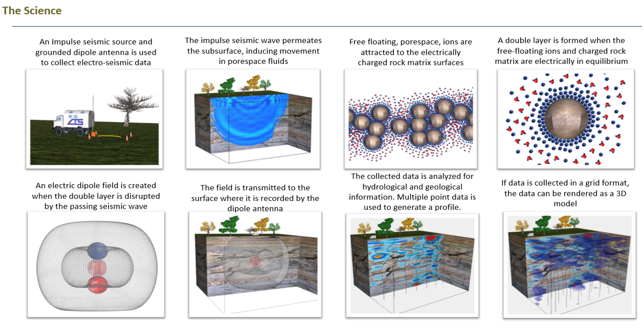
Electro-Seismic Technology
Aquifer Mapping is powered by New Zealand made, world leading, AI assisted systems.
It detects fluids directly within the subsurface, providing clearer insight into aquifers, water movement, permeability, porosity, and geological interfaces.
Because the system responds to fluid-saturated geology, it delivers improved depth accuracy and a more practical understanding of groundwater behaviour.
This makes Aquifer Mapping particularly effective for water exploration and sustainable environmental subsurface management.
The machines are fitted to side by side motorbikes and the hammer is pneumatic. Most crews have one operator. All machines are fitted with Starlink and safety equipment including EPIRBS.
Important, The Aquifer Mapping technology does NOT require geo-phone strings, making it faster to deploy, more cost-effective, and easier to operate in the field.